

Take a virtual tour of Bayawan City in Negros Oriental, Philippines, its history, attractions, events & more!
Bayawan City
The Agricultural Capital of Negros Oriental, Philippines
Bayawan City has the largest land area in the province of Negros Oriental. This accounts for 13% of the province’s land area. Bayawan City have a relatively short coastline of 15 kilometers west to east and comprising seven (7) coastal barangays while it runs a long stretch of almost 60 kilometers from the south coast going to the northernmost portion.
Known as the agricultural capital of Negros Negros Oriental, as abundant harvest is always anticipated and the presence of the "Tawo-Tawo" or scarecrow had always been a great help to the farmers for several decades.
The majestic Niludhan Falls is the most popular tourist attraction of Bayawan City.
BAYAWAN CITY AT A GLANCE
Distance from Dumaguete City: 101.9 kms.
Land Area:
484.7 sq. kms.
Population:
110,250 (2007)
Fiesta:
Sto. Tomas de Villanueva celebrated annually on February 18
Places of Interest:
Niludhan Falls
Bayawan City boasts the distinction of being a "Character City," a member of the International Association of Character Cities and a pioneer Department of Health-certified "Healthy City" in the Philippines.
Recently, it was recognized by the Asian Institute of Management city as "one of the Top 10 Best Cities to Live In in the Philippines (Small Cities Category)" under its Competitive Cities Survey 2007.
A BRIEF HISTORY OF BAYAWAN CITY, NEGROS ORIENTAL
The coming of the Spaniards in the Philippines in 1521 as the harbingers of the Christian faith was not exactly met with approval from the natives living in the islands. When the Spanish missionaries set foot on the shores of Bayawan to spread Christianity, the “Maghats,” as the natives of Bayawan called, were very reluctant to give up their own faith in favor of Christianity.
Though peace loving by nature, the “Maghats” were dubious about the intentions of the strangers. Believing they were out to grab their lands, some of these natives fled to the mountains and waited for the perfect time to launch their assault. In the meantime, converts continued to live in the town center where a chapel was built.
One Sunday morning while the townspeople were gathered inside the chapel to hear mass, a tragedy occurred. As the priest hoisted the Holy Host in the act of consecration, a hostile and defiant Maghat barged in to the assembly and threw a lance on the priest, killing him.
This legend (or version) answers the question on how Bayawan got its name - from the word “Bayaw” or to hoist.
It was in 1872 when Bayawan was formally organized as a municipality . It was formerly known as Tolong Nuevo established by the Spanish friars in 1751 as part of Tolong Viejo which is now the Municipality of San Catalina.
Bayawan attained the status of a chartered city on December 24, 2000.
GEOGRAPHY
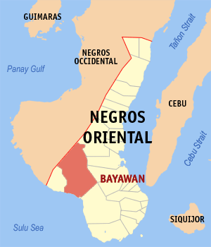
The municipality of Bayawan is 101.9 kilometers south of Dumaguete City; bounded by the towns of Mabinay, Bais City, Tanjay City and Pamplona on the north, the town of Sta. Catalina on the east, the Mindanao Sea on the south and the municipality of Basay on the west.
PHYSIOGRAPHY
Bayawan City is a fifth class component City of Oriental Negros located in the southeastern part of the province.
It has a total land area of 69,908 hectares, the largest in the province, and composed of 28 barangays (5 urban and 23 rural) . It is predominantly hilly. Basically, Bayawan is an agricultural town.
For several years Bayawan has earned the reputation as the “Rice granary of Negros South” . However, with the entry of agricultural diversification, farmers planted sugar cane, corn and coconut.
TOPOGRAPHY AND LAND FEATURES
The topographic characteristics of Bayawan is predominantly hilly with terrain moderately sloping to rolling.
The city has very rich water resources with surrounding rivers, springs, and even small lakes. There are four major rivers that pass through Bayawan: Sicopong River flows at the eastern side of the city; Ilog River at the northeastern side that defines the natural boundary towards the Municipality of Mabinay; Pagatban River at the western side which is also a natural boundary towards the Municipality of Basay, and Bayawan River that lies at the center.
The prevailing land utilization in the city is agricultural, with 44,384 hectares used as farmlands accounting for 63.49% of the total land area.
As the agricultural capital of the province, its vast lands are planted with sugarcane, rice, corn.
Livestock raising has also provided livelihood to communities.
POPULATION
The city has a population of 110,250 (National Statistics Office, as of August 1, 2007). Its population density is 1.58 person per hectare, which is still manageable compared to other cities in the country.
RELATED ARTICLES:
HOW TO GET TO BAYAWAN
Bayawan City is two-hour drive from from Dumaguete City along the coastal highway.
Regular bus trips are also available daily from Dumaguete, passing through the southwestern route, where folks can get on and off along the way.
THINGS TO DO
WHAT TO SEE
Niludhan Falls
WHERE TO STAY
Bayawan Pension House
Bliss Pension House
Blue Haven
Casa Rosario Pension House
El Oriente Lodge
Galsim's Inn
Joe's Place
La Vista de Mar
Oriente Lodge
Copyright © 2009. All Rights Reserved. Go Dumaguete! Your Gateway to Negros Oriental, Philippines